Walking around Zumaia
GR - 121 Zumaia-Deba
This walk, which is becoming more and more popular by the day, takes you around some of the most beautiful and interesting parts of the whole Basque Coast and into the area recently declared a coastal biotope, between Deba and Zumaia. In just a few hours, you can walk along the unbroken sequence of strata which, layer by layer, make up more than 50 million years of the history of our planet. There are a number of different routes between Deba and Zumaia, some of which even take you over the rocks. One of these routes, and the one that we recommend, is the GR-121, also known as the Round Trip of Gipuzkoa. This means that all you need to do to complete the walk is follow the red and white GR signs. You can follow the path in either direction, but we suggest travelling to Deba on the Euskotren train and then hiking back to Zumaia. From the Santa Katalina hermitage, the path takes you around a number of vantage points along the coast, giving you the chance to enjoy fantastic views of a wide variety of different landscapes. In the middle section of the walk, it is worth leaving the GR route for a moment to go to the edge of the impressive cliffs at Mendatagaina and Sakoneta. At low tide in the same area, you can also walk along the spectacular sea cut platform, where flysch outcrops have given rise to beautiful cliffs. Although it may seem unbelievable today, in the 1970s plans were being made to build a nuclear power station here. This whole coastline has a rich history of stories about smuggling, octopus fishing and many, many more.
Length: 15 km.(4h.45min) (Download KML)
GR - 121 Zumaia-Zarautz
You can take a gentle, enjoyable walk between these two coastal towns on the GR-121 trail, which runs parallel to the coast a few kilometres inland. If you combine your walk with the Euskotren train service or the local buses, you can get back to your starting point in no time. This walk takes you alongside some of the most notable cultural landscapes of Gipuzkoa: the txakoli vineyards that have made the area famous, some of which can even be found on the coast. From the footbridge over the Narrondo river in Zumaia, go along the estuary until you approach the Zuloaga museum. From here, you will start your ascent towards Askizu. The route is already marked, so just follow the GR signs. Once you have walked uphill for a while, the path goes through the coastal range, a relief which dominates Gipuzkoa’s coastline from the Bidasoa river. Walk up gradually and soon you will see Getaria below, with its characteristic San Anton hill. On the summit of Garatemendi, the highest point of the route, you can see the ruins of a fort dating from the Third Carlist War (1871-1876) which was built by Carlist troops with a view to attacking Getaria, a Liberal stronghold. You can see Mediterranean cork oaks here, in small copses or standing alone, even though they are a very rare species at this latitude. Their presence here bears testimony to a past with a very different climate from the one enjoyed by the area today. In the final sections of the walk you will come across some stretches of cobblestone track and before you reach the final descent towards Zarautz the path passes alongside the Santa Barbara hermitage. It is worth leaving the route for a moment here to take in the spectacular views of Zarautz, located by a coastal inlet, and other features of the nearby coastline.
Length: 9 km.(2h.) (Download KML)
GR-286 Araindarri: Zumaia - Loiola
GR routes are long-distance footpaths of 50 kilometres or more designed to take at least two days´ walking. You can walk the whole route or just Zumaia-Loiola section. The Araindarri Route, more commonly known as the Route of the Three Temples, is 67 kilometres from Zumaia to Arantzazu, connecting the three most important churches in Gipuzkoa: the Sanctuary of Saint Ignatius of Loyola, the Sanctuary of Arantzazu and the Hermitage of La Antigua.
Length: 25 km.(8:45h.) More information here.
Talaimendi - Algorri: geological walk
This walk takes you around the cliffs closest to Zumaia. Up until quite recently, these geological treasures, which reveal all sorts of intriguing secrets, were only known about by geology experts who travelled from far and wide to visit them. It is best to do this walk at low tide so that you can see the large wave cut platform that becomes visible when the tide is out. This walk sets off from Zumaia and goes up Talaimendi hill, the town’s old lookout point which was used, like other lookout points along the Basque coastline, to spot whales and keep the town informed about what was going on along the coast since the Middle Ages. The walk then continues along beside the cliffs on Itzurun beach until it reaches Algorri point. One of the most eye-catching features of this walk is the structure of the rocks, a formation known as flysch, which consists of alternating hard and soft layers (strata of sandstone and shale) which were deposited on the sea bed millions of years ago. Once these layers had been buried and transformed into rock, they were shifted by the Earth’s internal movements, which pushed them up until they were exposed to the erosive action of the sea. The waves act like a knife, cutting the rocky front, shaping a horizontal wave cut platform and creating a vertical cliff-face at the point where they can go no further. At Algorri point, amongst the layers of rock which come to the surface next to the sea, there is a layer which is 65 million years old containing particles belonging to an asteroid which collided with Earth during that period, and which probably caused the fifth mass extinction in the history of life on our planet. There are further two vertical layers next to Itzurun which are now officially-recognised stratotypes used as an international point of reference due to the quality of the outcrops. To find out more about this area and its interesting geological features, the Algorri Interpretation Centre is well worth a visit. You can also take part in one of the guided walks and boat trips which are organised on a regular basis by the tourist office in Zumaia.
Length: 4 km.(1h.)(Download KML)
Round trip of Zumaia
This route takes its inspiration from the annual walk around Zumaia undertaken by the town’s Indamendi mountain club. It is a very enjoyable walk which combines coastal and inland features, and most of the tracks are on cement or tarmac. The route will take you across the Urola river twice and through the small rural settlements of Artadi, Oikia, Ibañarrieta and Elorriaga, via a hilly landscape dotted with farmhouses. Because of the nature of the slopes that you have to go up and down along the route, we suggest that you follow the path in a clockwise direction. The tracks are also suitable for mountain bikes, although if you decide to cycle you may find it easier to come off the route suggested here for two short sections: halfway around the walk it is best to turn off towards Arroa and join up with the path a little later, and at the end of the track you can follow the last tarmac section which takes you directly to Zumaia.
Length:: 18,5 km. (Download KML)
Zumaia - Artadi - Askizu
This is a very gentle walk, which gradually takes you up to 200 metres above sea level. It includes several vantage points with excellent views, and offers the incentive of walking through the txakoli vineyards. Part of the first ascent takes you along the main road towards Artadi, but you will cover this stretch of road quickly, there is very little traffic and it offers the incentive of being able to walk through a wonderful holm oak wood. A few minutes after you leave Artadi, the walk continues uphill. Soon afterwards, as you get closer to Garate Gaina hill, you can enjoy fantastic views of Oikia, the Urola valley, the Izarraitz massif, Indamendi and other nearby hills. Shortly after this, the path leaves the Cantabrian holm oak wood, and you will start to see the txakoli vineyards, which are gradually covering more and more of the land in this area and other coastal areas near Getaria. If you do this walk in September or October you may see the vineyards at harvest time. Just a few weeks after the harvest this young wine, which up until recently was made exclusively in this area and is becoming increasingly popular, will be ready to drink. Keep walking and soon you will reach Askizu. The road to the coast used to pass through this small village, until the new road was built a little over a century ago. Here, the path joins up with the Coastal Route of the Way of St. James. Along the path back you will be able to enjoy fantastic views of Zumaia and appreciate its exceptional setting.
Length: 9 km.(Download KML)
Zumaia - Elorriaga
The best thing about this walk is that it gives you a chance to see several of Zumaia’s most important features - the Urola estuary, the gentle hills and farmhouses on the way to Elorriaga, and the impressive coastal cliffs - in just a short period of time. Near the beginning of the walk, after you have gone around Foronda Palace, on the first ascent towards Amezmendi, there is a poorly-marked footpath. Make sure you pay attention here so that you do not get lost. Shortly after this, you will walk up to various vantage points where you can enjoy good views of the estuary and imagine what Zumaia was like a few centuries ago: a small walled settlement of houses surrounded by an extensive estuary with marshland that flooded at high tide. The path continues through a very pleasant landscape dotted with farmhouses and hills, then climbs up a gentle slope to Elorriaga, a peaceful rural settlement next to a small San Sebastian hermitage. There is also a bar here which serves food and drinks. From here the route gradually heads back to the sea via a gently undulating landscape that terminates abruptly at spectacular cliffs overlooking the tidal plain. The path then descends and on the last section hugs the cliffs very closely until reaching Algorri, one of the most magical places on the Basque coast, finally ending at the chapel of San Telmo above Itzurun beach and Zumaia.
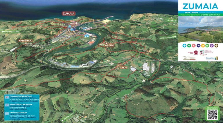
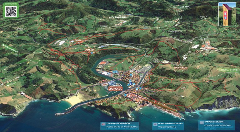
Public rights of way in Zumaia
The Zumaia City Council has recovered and marked out public paths that have historically linked Zumaia with surrounding towns.
In the map bellow, you will find an inventory of them and you will be able to identify the type of signal you can follow.
The paths of other municipalities that may be a continuation of these are also marked in another color, in order to make longer routes.
You can download here the map in pdf format.

 turismoa@zumaia.eus
 Bulegoa


